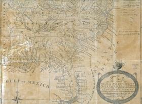
This 1783 map produced by Joesph Purcell and originally published in 1788 depicts the new political borderes between
Spanish East and West Florida, and the United States. The includes very detailed depictions of towns and cities
in the southeast, including major roads and trails connecting communities.
Notice the several dotted trails leading to and from Penscaola, then the headquarters of the Panton,
Leslie and Co. trading house.
Changes in the spelling and general location of indegenous communities has changed in this map, including the
inclusion of the "Seminolas" located in north central Florida.
1783 Purcell Map


